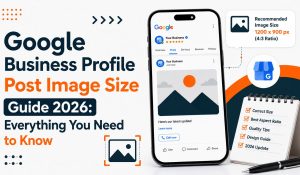
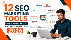
Mind Mingles Logo

Google Map

Google Maps Marketing
Google Map

Google Maps Marketing Tips 2024: Improve Business Visibility

Have you ever paid attention to how Google returns search results? When a person searches for “restaurants/mobile repair shops/dentist/__ near me/in __(location),” it returns Google Maps results (also referred to as Google Local 3-pack or Google 3-pack). Just imagine a person looking for a certain store will definitely most intuitively click on those top 3 results first. In this case, if you aren’t taking advantage of Google Maps marketing, you’ll miss out on a great opportunity to attract new clients. The Google Local 3-pack returns results with three top business listings relevant to the search and near to the area searched in the query and their Maps location. This shows users the overall business information: their working hours and days, time, location address, photos, about, reviews, and a lot more. In this article, we’ll dive deep into top tips to optimize Google Maps marketing strategy. So make sure you read it until the end….. What Is Google Maps Marketing? Around 67% of smartphone users head to Google Maps for navigation purposes, WifiTalents confirms. This resulted in businesses shifting their promotional strategy to focus on Google Maps marketing. It involves activities businesses utilize to showcase their listing on Google Maps on top. From obtaining a GBP listing to utilizing an SEO-friendly approach for boosting Google Maps position, there are several ways to foster your business’ visibility. For one thing, Google Maps receives over 69000 search queries in a second– there is no way businesses can overlook promotions on this platform. That’s why businesses follow diligent Google Maps marketing strategy and improve their business’ visibility on this app. This also improves chances of appearing in Google Local 3-pack. Google Maps Marketing– Optimization Tips For Business Promotions These tips will improve your business’ online visibility on Google Maps, increase foot store traffic and lead conversion: Create/Update GBP Listing (previously Google My Business) Today most people look for a business on Google before reaching it out for a service/product. Google Business Profile (GBP) listing provides businesses a non-chargeable service allowing businesses to manage visibility and information over the web. It acts as a virtual business card that provides all the necessary information for prospects. This information includes–  business name address contact number working hours reviews ratings about  appointment link Claiming a GBP listing is crucial to achieve a rank in Google Local 3-pack which returns three top business listings based on the proximity of users’ location and relevance to their search. Unfortunately, many people think that their work is over once they created the GBP listing. However, the case is quite contrary and it is Step 1 in the direction of Google Maps marketing. You must make efforts to optimize your GBP listing by: Updating business hours/holidays Responding to users’ queries or reviews Regularly updating Google posts about offers/events You can check the Profile Strength Score in the top-right corner. And the best part? Claiming a GBP listing for your business is free. Learn how to register for Google Business Profile and boost your search visibility across Google’s platforms including Maps. Verify Your GBP Listing Another important step you need to initiate before making effective utilization of Google Maps for promotions is getting your business listing verified. There are multiple ways to verify your GBP listing: Phone or text message Email Video Recording Live Video Call Mail It can take around 2 weeks to get your listing verified. For businesses operating in multiple physical locations, bulk address verification option is there. Utilize Google Posts Google Posts are a feature in Google Business Profile (GBP) listing wherein businesses can share posts related to any announcements, events, offers, or promote products/services. This appears on Google SERP and Maps allowing prospects to go through business updates and remind them about your company.  Consistently updating Google Posts not only elevates the chances of your business coming across a wider audience base but also significantly puts across any: new product/service launch upcoming/special offers/workshop/seminar  holiday wishes customer testimonials awards and achievements Simply follow these steps to create a Google Post: Login to your Google Account (the one with which you created your GBP listing) and search for your business name on Google. Then hit the “Promote” or “Add Update” option. To proceed, choose the post type from the given options (offer, product, update, or event). Enter the relevant details in the given box and adhere to the character limit. In case of an event post, you’ll need to provide the start date, end date, and title. GBP provides an option to add event details (time, venue, date, etc.) which acts as an amplifier for Google Maps marketing. Add a CTA (Book Now/Shop Now/Sign Up/Register/Learn More, etc.) to redirect the visitors to the desired landing page. Provide an image relevant to the context of your Google Post. Recheck the details and hit on the “Post” tab. Your audience on searching your business name will get to see the Google Posts under the Updates/Products/Events tab in the GBP listing. Entertain Questions Answering your prospects’ queries is another splendid thing to get noticed by your audience on Google Maps. Several businesses don’t pay attention to queries until a person really reaches them, however, they must understand that it doesn’t work in their favor. Prospect’s queries must be resolved as soon as plausible. Some of the most obvious questions the audience can ask are: Is your hotel/store pet-friendly? Is parking available there? Does your restaurant have seating and arrangements for a party of 50?  While answering the questions, you must remember to use the business account that you used to make your GBP listing. This will mark your response as “Owner” which makes it more reliable for the prospects.  Ask For Reviews Reviews are another crucial element of Google Maps marketing strategy because they hold the power to influence people’s purchase decisions. It’s sort of intriguing for prospects and they first land there to check what your previous clients have to say about you. So make your review gathering approach diligent and utilize

Google Maps Advertising
Google Map

How To Do Google Maps Advertising 2024: Cost, Tips, Benefits

Google has increased the horizons of its advertising arena for quite some time now. With featured listings on Google Maps, businesses can now claim a distinct identity of their own. This will help them  garner traction the next time someone hits the search button after typing “__ store near me” on Google or Google Maps. If this sounds like an intriguing opportunity to you, then this detailed blog is for you as it unveils what is Google Maps Advertising, how to do it, and how it can benefit local businesses. What Is Google Maps Advertising? Google Maps advertising will make your business listing appear in front of relevant and nearby audiences with Google ads. With Maps serving over 1 billion users from across the globe, businesses have a fantastic opportunity to attract customers from their local area. Advertising on Google Maps can be done in more than one way and that’s the best part because based on the budget and audience relevance, businesses can connect to the global marketplace. Google Maps ads work like PPC wherein advertisers pay for each click when a user lands on their ad. One thing that people often overlook about Maps advertising is that it isn’t any mere promotional strategy for location-based searches in Google Maps, but can also elevate their digital marketing strategy. How Do Google Maps Ads Work? Google Maps Ads work wonderfully on both desktop and mobile devices, which gives users a robust mechanism. Once an ad is created for Google, it comes into users’ sight when they use the Maps app on mobile, or desktop or run a search on Google. So the next time you want to publicize your business on Google, you know where to go for triple exposure. Features Of Google Maps Advertising Here are the features of Google Maps ads that set apart Sponsored listings from standard business listings: 1. Sponsored Local Search Results Search result adverts appear when a user searches for a particular business on their mobile device. Usually, businesses with paid local ads appear on top with a highlighted tag of “Sponsored.” Such ads provide optimum exposure to businesses who don’t want to lose their grip on the market even by a bit and establish themselves as a notable identity in their respective industry. Although these ads work on a location-based premise showcasing the nearest business spot on the top, some paid listings can influence the search results in some areas. 2. Promoted Pins Promoted pins work like a wonder in Google Maps as they display as a separate eye-catching square pop-out or brand logo even if someone is not searching for your business primarily. In other words, these pins captivate users’ attention while they are searching for any place or business. This elevates the chances of people coming across the existence of your business in an impactful manner. They also feature a landing page redirection and improve website traffic as well as local foot traffic. As you can see in this image, Singh Physiotherapy Center has invested in paid promoted pins on Google Maps.  3. Promoted Pins along the Route These appear when a user searches for a route on Google Maps providing their current map location and the final destination. The only difference is that such ads show an option of “Add Stop” which when tapped/clicked on adds the place as a stop in users’ route. 4. In-store Promotions With Google Maps ads, businesses can promote offers, discounts, and special arrivals. This helps them attract customers to new deals, and escalate their store traffic and revenue.  The image shows how Godrej Interio’s ad on Maps shows 35% off on furniture sales. People interested in the deal can visit the link and discover more about the same. 5. Featured Customer Reviews Google Map advertising allows businesses to display their customers’ feedback and reviews while on the app. This is a critical part of fostering brand credibility and search engine rankings because your online reputation in front of your audience can be boosted with genuine, authentic, and positive appreciation. 6. Customizable Business Page Google search ads returns a landing page with a Visit Site tab, Directions button, Website button, location sharing options, overview, reviews, and about. The online information on your Google Business Profile and ads automatically updates the key changes on the Maps sponsored pins and also allows people to chat using the new Google Business Messages feature. 7. Local Search Inventory Local search inventory when integrated with Google Maps, allows businesses to display their stock to the interested audience, pickup/delivery options, and triggers them for purchase action. These ads when enabled display the storefront to users and help make them land on the desired page. This can be done by updating either GBP or Google Merchant Center and then integrating it with Google Maps. Here is the link if you want to know how to start local search inventory ads on Google Maps. Benefits Of Google Maps Advertising Capture More Foot Traffic: With Google Maps local search advertising, businesses get to leverage the opportunity to attract clients from places near their palace of operations. This increases the foot traffic and helps establish prominence and credibility among the local audience. Sharing business details like place, operation hours and days, website links, etc. can help get essential information in front of the audience in an effective manner. Book Leads Online/Over a Call: Today where people book most of their appointments online, Google Maps attracts a varied audience by displaying both contact numbers and website details for customers. This eases the process, reduces delays, and promotes a feeling of direct contact with businesses in just a few taps/clicks. Display Your Reviews: Have you been using your ORM strategy right? If not, then Google Maps ads are the right choice to invest in as they flail satisfactory remarks in front of people, establishing trust in your business name. Attract With Images: Businesses have a wonderful option to add images of their place of operations, store,

How To Share Location On Google Maps
Google Map

How To Share Location On Google Maps 2024 on Android/iPhone?

Sharing Google live location is a phenomenal feature of Google Maps. Gone are the times when people used to explain routes like from which street to enter and where to turn over the call. Now you can share your whereabouts with your family and friends by sending live location on Google Maps. Do you know that learning how to share location on Google Maps is super simple? This article will familiarize you with the entire process of Google Maps location sharing. How To Share Live Location On Google Maps 2024? Sharing live location on Google Maps allows you to send your real-time location to individuals or in groups. You get to enjoy full control over how long you want to share the location and when you wish to stop sharing it.  Sharing Google live location Android/iOS Launch the Google Maps app on your smartphone or tab and make sure you’re logged into your Google Account. Then tap on your profile icon (appearing in the top-right corner).   Next, tap on Location Sharing. On the next screen, you’ll see an option of Share Location, but before that learn what information will be shared and be mindful of certain things that’ll be shared with the person or group. It includes: your name and photo device‘s recent location, even if you’re not using a Google service. battery power of your device arrival and departure time NOTE: This information will be shared until/unless you will stop sharing your Google location and disable Location permissions. So be considerate about what you share and with whom. Once you hit the Share Location option, you’ll be headed to select from the contacts with whom you want to share the live location. If the name of the person with whom you want to share a live location doesn’t appear, tap on More and search for it. Ensure that your Location access and other necessary access are granted to the app. Furthermore, you can select for how long you want to share the location. You have the option to share indefinitely by selecting “Until you turn this off” or increase/decrease the timeframe by tapping on the +/- icon next to the “For 1 hour” option. Then tap on Share. Google Maps will send a link to the receiver giving them access to track your real-time location, battery of your device, and other things mentioned in Step 3.  The process is the same on the iPhone. In case you want to share your live location via Gmail or any other app, you can do that by scrolling through the app icons in the bar just below the contacts.  How To Share Location On Google Maps If The Other Person Doesn’t Have Google Maps App? Google Maps is nowadays an in-built functionality that comes pre-installed and is operational on most Android and iOS devices as well. However, there might be certain nuisance situations where you can’t use the app as desired. In such a case, go to your Google Maps app, head straight to your profile icon, and then select the Location Sharing option. Then Share location > Gmail > Share. Google Maps will generate a link for sharing your real-time location. This link will allow anyone to see your real-time location details until you Stop Sharing.  How To Share Live Location On WhatsApp?  Sharing Google location on WhatsApp is quite a common practice, and is easier than you can think: Launch the WhatsApp app on your phone. Open the chat with the person or group with whom you would like to share the location. On the right side of the message box, you’ll see an attachment icon (for Android)/ (for iOS), tap on it. Then select Location. Once you hit that option, you’ll be required to allow the necessary permissions like GPS and location access. The next step is to select the Share Live Location option and choose the duration for which you wish to share your real-time location details.  Add any comment or emoji if you want to. Finally, tap on the Send icon . How To Share Current Location On Whatsapp? Unlike live location sharing wherein the other party will be able to keep a tab on your real-time whereabouts, Current Location sharing or share my location feature allows you to send the exact location of yours in the present moment. You guessed it right– you won’t be able to share your location straight for like 15 minutes, 45 minutes, 1 hour, and so on.  So when you want your friend to pick you up from a spot, sharing your current location is the best idea. Open chat with your contact (to whom you want to send your location). Then tap on the attachment icon (for Android)/ (for iOS). Select Location > Share Current Location. That’s all, your current location will be shared the very moment with the person on the other end. Google Maps ETA (Estimated Arrival Time) Have you ever planned a trip with friends meeting them on a spot on a decided date? Well, ETA can be very helpful in such scenarios as it allows you to share your estimated time of arrival with your contacts. This feature of Google Maps is enormously used by logistics companies and delivery partners who have to plan out everything in advance and share details about their expected arrival time.  ETA is determined using real-time and historical traffic data, plus speed limits as well as distance, however, it is influenced by several uncontrollable factors, for instance– the breakdown of the e-car. After all, there is a reason it is called “estimated” arrival time. In the Google Maps app, enter the destination and your start/current location. When you leave for the trip, click on the arrow (^) and choose Share trip progress. Now select the contact person with whom you wish to share your ETA. This will share your real-time progress on your route until you reach the destination or stop navigation. The process of sharing ETA on iPhone

Google Map

How to Measure Distance on Google Maps: A Step-by-Step Guide

Google Maps is an incredibly useful tool for navigating the world, planning trips, and even measuring distances. Whether you’re calculating the distance for a run, planning a road trip, or just curious about how far one location is from another, Google Maps makes it easy. This guide will walk you through the process of measuring distances on both the desktop and mobile versions of Google Maps in a simple and relatable way. Why Measure Distance on Google Maps? There are many reasons you might want to measure distance on Google Maps: Planning a trip: Estimate how far your destination is from your starting point. Exercise tracking: Calculate the length of your walking, running, or cycling route. Property measurement: If you’re curious about the size of a plot of land, you can measure its area. General curiosity: Simply wondering how far apart two locations are. Google Maps offers two main types of distance measurement: Straight-line distance (as the crow flies): This is the direct distance between two points. Route distance: This is the distance based on the actual path you would take, such as driving, walking, or biking along roads or trails. Let’s see how to use Google Maps to measure distances in both ways. How to Measure Straight-Line Distance on Google Maps (Desktop) The desktop version of Google Maps allows you to measure the straight-line distance between two or more points, giving you the direct distance regardless of roads or obstacles. Step 1: Open Google Maps Go to Google Maps on your desktop web browser. Step 2: Select a Starting Point Right-click on the starting location on the map. From the dropdown menu, click “Measure distance.” A small white circle will appear, marking your starting point. Step 3: Add the End Point Left-click on the location where you want to measure the distance to. A line will appear between the two points, showing the distance in a small box at the bottom of the screen. Step 4: Measure Multiple Points (Optional) If you want to measure a distance with multiple stops, simply continue clicking on additional points. Google Maps will add the distances together and show the total distance at the bottom. Step 5: Clear the Measurement To reset or clear the measurement, just right-click anywhere on the map and select “Clear measurement.” Read More: Complete Guide to How Often Google Maps Updates: Frequency, Statistics, and Processes How to Measure Distance on Google Maps (Mobile) You can also measure distances on the Google Maps mobile app, which is available for both Android and iOS. Step 1: Open the Google Maps App Open the Google Maps app on your smartphone. Step 2: Drop a Pin Find your starting location by either searching for it or scrolling on the map. Tap and hold the map at your desired starting location until a red pin appears. Step 3: Start Measuring Once the red pin appears, at the bottom of the screen, tap the location name or address. Scroll down and select “Measure distance.” A line will appear on the map, just like in the desktop version. Step 4: Add the End Point Move the map so the crosshairs hover over the second point (your destination). Tap the blue “Add point” button to place your next point. The distance will automatically update at the bottom of the screen. Step 5: Add More Points (Optional) To measure a more complex route or multiple distances, keep adding points by moving the map and tapping “Add point.” Step 6: Clear the Measurement To start over or clear your measurement, tap the back arrow at the top left of the screen. Read More: How To Drop A Pin In Google Maps : Android, iOS & Desktop How to Measure Route Distance on Google Maps If you’re more interested in measuring the distance of a route you plan to take—whether by car, bike, or foot—Google Maps provides this feature with directions. Step 1: Open Google Maps Open Google Maps on your desktop or mobile device. Step 2: Input Your Starting and Ending Locations Enter your starting location in the search bar. Click the “Directions” button. Enter your destination in the “Choose destination” box. Step 3: Select Your Mode of Transportation Choose whether you’re traveling by car, foot, bike, or public transportation by selecting the corresponding icon. Google Maps will calculate the route based on your selected mode of transportation and show you the total distance and estimated travel time. Step 4: Explore Alternative Routes (Optional) Google Maps may show you multiple routes. You can compare the distances by selecting different routes to see which is shorter or faster. Tips for Measuring Distances on Google Maps Zoom in for accuracy: If you’re measuring smaller distances or want pinpoint accuracy, zoom in on the map to ensure you’re selecting the exact locations. Switch between miles and kilometers: Google Maps typically defaults to showing distances in miles or kilometers based on your region. To change the units, go to Google Maps settings and switch between imperial (miles) and metric (kilometers). Measure area: In the desktop version, you can measure the perimeter and area of a space (like a park or field) by clicking multiple points to enclose the shape. Read More: A Complete Guide to Google Maps Marketing Common Uses for Google Maps Distance Measurement Runners and cyclists often use Google Maps to measure the length of their routes before heading out. Real estate professionals can measure property sizes or distances to nearby amenities. Hikers and travelers use the tool to estimate the distance of trails or roads before starting their trips. Homebuyers may want to measure the distance from a potential home to schools, stores, or workplaces. Conclusion Measuring distances on Google Maps is a simple yet powerful feature that can help you plan trips, estimate travel times, and even track exercise routes. Whether you’re measuring a straight line between two points or the actual route you’ll take, Google Maps makes it easy and accessible for everyone. By following the

Google Map

Complete Guide to How Often Google Maps Updates: Frequency, Statistics, and Processes

Google Maps is an essential tool for navigation and location-based services. It is one of the most widely used mapping services globally, offering a wealth of information from street views to business listings. Given its extensive use, understanding how often different components of Google Maps, such as Street View, satellite images, Earth images, traffic data, street names, routes, business information, and more, are updated is crucial for users who rely on the platform for accurate and current information. How Often Google Maps Update Let explore how often Google Maps updates and its different components, the steps involved in these updates, and relevant statistics. Google Street View Google Street View provides panoramic images of streets and locations around the world. The frequency of updates depends on various factors:   Update Frequency: Urban Areas: Every 1-3 years. Rural/Remote Areas: Every 5-10 years or more. High-Priority Locations: As frequently as every year if significant changes are detected. How Updates Are Made: Data Collection: Google Maps cars equipped with 360-degree cameras capture imagery as they drive through cities and towns. They also use Trekker systems (backpack-mounted cameras) for areas inaccessible by car. Image Processing: Collected images are stitched together to create panoramic views. Faces and license plates are blurred for privacy. Publishing: After processing and quality checks, the images are published on Google Maps. Statistics: As of 2023, Google Street View covers over 16 million kilometers of roads across more than 85 countries. Over 220 billion Street View images have been captured. Satellite Images Satellite images on Google Maps and Google Earth are sourced from various satellite providers. Update Frequency: Urban Centers: Every 1-3 years, potentially more frequent depending on the area’s significance. General Areas: Every 3-5 years. Remote Areas: Every 5+ years or when significant changes are detected. How Updates Are Made: Data Acquisition: Google sources satellite imagery from various providers like Maxar Technologies, Landsat, and other government and commercial satellites. Image Processing: Images are processed to remove clouds, adjust colors, and improve clarity. They are often composites of multiple images taken at different times. Publishing: The processed images are integrated into Google Maps and Google Earth. Statistics: Google Maps uses data from over 800 satellite sensors. High-resolution imagery covers over 98% of the world’s population. Google Earth Images Google Earth shares satellite imagery with Google Maps but includes more historical data. Update Frequency: Priority Areas: Updates can occur as frequently as every few weeks. General Areas: Every 1-3 years. Remote Regions: Every 5+ years. How Updates Are Made: Historical Data: Google Earth often integrates both current and historical imagery, allowing users to view past landscapes. 3D Imagery: Uses stereoscopic techniques to create 3D models of terrain and buildings. Publishing: New and updated images are periodically rolled out in Google Earth. Statistics: Google Earth contains over 10 petabytes of imagery data. Historical imagery is available in Google Earth Pro for various locations, allowing users to see changes over decades. Traffic Data Traffic data on Google Maps is updated in real-time or near-real-time, thanks to various sources: Update Frequency: Real-Time Data: Updated every 1-2 minutes based on live conditions. Historical Traffic Data: Aggregated and updated periodically based on new data trends. How Updates Are Made: Data Collection: Google collects data from GPS signals, mobile devices, and partnerships with traffic authorities. Data Processing: Algorithms analyze the collected data to determine traffic flow, congestion, and incidents. Publishing: Traffic conditions are displayed in near real-time on Google Maps. Statistics: Google Maps processes billions of real-time data points every day. Traffic data accuracy improves with the number of active users, making urban areas more precise. Street Names and Routes Google Maps updates street names, routes, and road information regularly. Update Frequency: Major Urban Areas: Updates can occur within weeks of changes. Rural Areas: Updates may take months, depending on the availability of new data. How Updates Are Made: Crowdsourcing: Users submit corrections or new information, which are then verified by Google. Data Partnerships: Google collaborates with local governments, mapping agencies, and businesses to get the latest data. Algorithmic Updates: Automated systems detect changes in road patterns and names based on various data inputs. Statistics: Google Maps has over 1 billion active users who can contribute to map corrections. Each day, over 25 million updates are made to Google Maps globally. Business Names and Information Business listings on Google Maps, including names, addresses, phone numbers, and hours of operation, are updated frequently. Update Frequency: Real-Time Updates: Business owners can update their listings instantly. User-Reported Changes: Verified and updated within days to weeks. Automatic Updates: Continuous, as Google crawls the web for new information. How Updates Are Made: Business Listings: Owners claim their businesses on Google My Business and update information directly. User Contributions: Users can suggest changes to business names, hours, and other details. Web Crawling: Google’s algorithms search for business information across the web and update listings accordingly. Statistics: Google Maps contains information on over 200 million businesses and places. Over 5 million business updates are made every month by users and business owners. Public Transit Information Transit data is updated frequently, often in real-time for arrival and departure times. Schedule updates typically occur as soon as the transit authorities provide new data. Update Frequency: Real-Time Data: Updated every few minutes, especially in major cities. Schedule Updates: Updated as soon as new schedules are released by transit authorities. How Updates Are Made: Data Integration: Google partners with transit agencies to integrate real-time arrival and departure data. Crowdsourcing: Users can report delays, changes, or inaccuracies. Algorithmic Adjustments: Based on historical data and real-time conditions, Google adjusts the predicted arrival times. Statistics: Google Maps provides public transit information for over 80 countries. More than 1,500 cities globally have real-time transit data integrated into Google Maps. Points of Interest (Parks, Landmarks, etc.) These are updated based on new developments, user submissions, or governmental data. Updates may range from a few months to several years depending on the location and significance of the changes. Update Frequency: High-Interest Areas: Updated as new

Scroll to Top

Book Your Package